The Suwanee River Wilderness Trail

101 miles. . . 5 days, 4 nights, 3 paddles, 2 people, 1 boat
I took every photograph that will be used in this series with Reema's Canon G11 point-and-shoot Camera, except for a choice few I took with my Canon 1000d/50mm lens.
I am going to start posting my Suwanee River trip day by day, as the full 5 days in one post has seemed like too much of a daunting task and I've been putting it off for a few weeks now.
So, here it is. Chris Matechik and myself paddling 101 miles down one of America's most famous rivers! We used our free time during Spring Break basking in the sun while paddling for more than 6 hours a day.
We spent all of 2-3 hours planning for the trip since we have a great deal of paddling experience. Chris found the trail online when searching for the best parts of the river to paddle. We chose our particular portion of the Suwanee river (which reaches almost 300 miles if you do the full trail) because of the convenience of the rivers pattern.

If you take a look at the map above we began our trip by dropping off my car in Branford, Florida to be used as the means of getting back to Chris' jeep when the trip was over. The greatest logistical thing Chris discovered was how the river arcs the 100 miles we paddled, so in the end we only had to drive 41 miles to our boat launch, not even a 40 minute drive. Chris also found out that the Suwanee River Wilderness Trail (SRWT) has River Camps along its banks. The river camps were made in the early 2000's as a mean to draw eco-tourists to Northern Florida.
We launched the boats in Big Shoals state park about 5 miles outside of the city of White Springs, Florida.
Day 1

Paddling time and mileage (3:30PM-11:30PM, 17 miles)
Chris and I actually had a similar drive to Branford, a little over 2 hours. I took some back roads just outside of Gainesville up to the river, and he drove down from I-10 near Live Oak. We met around 12:30PM, not a bad start considering most of our camping and river trips start around 11PM at night. The catch is, we didn't get onto the river until 3:30PM. THREE HOURS YOU SAY? Let me explain.
So, according to Chris, state parks and the state itself don't work very well together. Big Shoals state park is marked as a launch for the SWRT, but here's the catch. THERE IS NO PARKING OVERNIGHT. Considering we'd be gone for 5 days, we thought that might be considered as an overnight venture.
Now, trying to find a new place to park wouldn't have been such a big deal. But, we had a problem. Chris wasn't interested in filling up his tank until AFTER the trip, and we were running on the "Low Fuel" light sometime back in Lake City, and we were about 5 miles from the nearest gas station. Driving around for other parking places wasn't the best idea, so we decided to do something drastic.
The ranger stationed at Big Shoals State Park was not at his home when we arrived, and we had no idea what to do with the car at that point. Defeated and frusterated, we drove back towards the main road to head back into town. Until, Chris and I saw a guy who lived in one of the only two houses on the road to the park.
Of course, I decided we should try and ask this guy for directions, hints, hiding spots; I told Chris to stop the car. I jumped out and we happened to meet Allen, the most welcoming person we met on the trip. He owns a small engine repair shop and works for the state (I think), just outside White Springs.

The 'N' on his sign may be faded off, and the drawings may not be professionally photoshopped, but Allen was a stand up guy. If you happen to need a lawn mower or chain saw fixed in the Lake City area, he's your guy.
Basically, Allen told us the ranger would probably let us park in his driveway, but he was no where to be found. We were also able to park down in White Springs, but we would lose the first 5 miles of the trip and not get to see Big Shoals (which turned out to be awesome and totally worth the trouble). So, with a little reluctance and hopefulness, Chris and I asked if we could leave the Jeep in Allen's yard. He scratched his head and said, "I think that'd be fine."
With great relief, but a little worry that the Jeep might be missing when we returned, we parked and grabbed our bags to begin the journey back to the river (about 1.5 miles).
Allen's generosity went even further, he and his buddy offered to take us back to the river so we wouldn't have to walk. We owe you Allen! He stated that he,"wouldn't pass up an opportunity to avoid doing work."
Allen's generosity went even further, he and his buddy offered to take us back to the river so we wouldn't have to walk. We owe you Allen! He stated that he,"wouldn't pass up an opportunity to avoid doing work."

Allen and his buddy driving off after graciously driving us to the State Park
After our run-in with a nice local, Chris and I were in high spirits to get the trip started. It had been 3 hours since our first rendezvous, but now we could put the paddles through the water!
The paddling started off great, the first part of our trip contained narrow river which was far easier to navigate than the lower parts that get extremely wide. There was the occasional portage over fallen logs, but I think the narrower river is still preferable.
After a few miles we heard the roar of Big Shoals just around the corner. We found the portage that everyone had mentioned to us. Since going through the shoals with all of our gear we needed for the next five days might be hazardous, we decided to carry all of the food and dry bags to the other end. It was only about a quarter mile to get the stuff down to the other end, but we had to make multiple trips.

Chris gathering bags to take by land

The portage itself was a nice walk
After portaging, we suited up with life-jackets and got ready for the Shoals, which are sometimes class III rapids depending on the level of the river. Since it was early March, the river was actually low and the rapids were a little rocky. When first approaching the rapids, its a little terrifying. You can see the river a couple hundred feet ahead, but it looks like it falls about 30 or 40 feet. We braved the rapids, and actually got stuck on a rock in the biggest drop and I took on about 5 gallons of water and was thoroughly soaked. The rapids were definitely were the extra hassle of parking! Here are some pictures of the rapids, and Chris and I gallivanting throughout the river without shoes (not the smartest idea in sharp rocks!).


Onto the rest of Day one, which isn't all too exciting. We finished the rapids and paddled on towards the setting sun and our first camping site, Wood's Ferry. The day had been relatively hot, high 70's to low 80's. I had checked the weather before the trip, but I apparently disregarded it. The forecast had foretold of colder weather, but my Floridian upbringing had convinced me that it couldn't be cold in March. I was in for a rough couple nights. By the time the sun went down, the temperature dropped something like 20-25 degrees. The thermometer was pushing the high 40's and the wind was blowing in. I had the equivalent of a poncho for cold weather clothing, and the first night was pretty rough. I put on some long-johns I brought for sleeping at night, and layered shorts and shirts all over my body. I had not a single pair of pants, and nothing but t-shirts and one rain coat. I learned my lesson that night, be prepared!

This is me on the second night, but it gives you an idea of my lack of warm clothing
So, Chris and I paddled furiously to get to our first river camp. I was a little delirious from lack of sleep, food, and warmth and babbled about hearing cars on I-10 just around the next river bend for about 3 hours. Chris got fed up with me and we eventually paddled in silence for the last 2-3 hours until we reached our destination.
Everyone was asleep in the river camp except for a few guys that were hanging out having a few brewskies and smoking. They were nice, but were a little too far gone to have a decent conversation with. Chris and I got into our little sleeping hovel and made a big dinner.

We didn't realize until the next day that cooking in the platforms isn't allowed, something about wood and fires.
We ended up eating peanut butter crackers, clementines, a huge piece of Ham Chris had gotten around Christmas-time (yeah, 3 months before), and half a can of baked beans. We made sandwiches with the Ham and used the baked beans as a topper. Oh yeah, the bread we used for the sandwiches. Chris went out and bought 7 loaves of Jimmy John's bread the day before we left on our trip. We ate bread all day, every day for the first three. We made sandwiches, ate it plain, put peanut butter on it. The lack of nutrients in it was probably not good, but it gave us easy carbohydrates!
Needless to say, crawling into our sleeping bags at the end of the first cold day was fantastic. We fell asleep quick, and were ready for another day!
Day 2
I almost fell off of a 15 foot cliff trying to take this photo
Paddling time and mileage (10:00AM-4:30PM, 19 miles)
I'll be honest, the first night got my spirits down. I was ready to turn back, we still had some 85 miles to go and I was already cold and tired. But, the good news is our spirits only got better and better as the trip went on. In fact, the paddling got easier day by day. Chris and I have done plenty of short paddling trips on Coldwater, Blackwater, and others. 19 miles seemed like a short amount, and it turned out to be. We even had plenty of time to stop and look around at some native wildlife and meet some cool (and not so cool) people. We had breakfast which, as most of our breakfasts, consisted of clementines. I also ate the rest of the baked beans (cold) for some sugar and protein (yum!).
We smelled something awful, and we were convinced one of the canoers from a previous trip the week before had bought the river and been hanging out the past few days. In the end, we found a bloated beaver corpse. Beavers are actually considered pests, and farmers have a legal right to kill them just as they would gophers. The weird thing was, we found 2 more beaver corpses while paddling. We were convinced some new strain of a disease was wiping out the beaver population on the Suwanee.
Despite the interesting cadavers, we had few other encounters in the morning. Until we heard people yelling "HUP" about every 3 seconds from behind us, and the sound of moving water. Someone was approaching us fast. Chris informed me, as about 4 carbon fiber canoes passed us, that they were probably racing. It turns out they were a group of people from Canada that were training for a race. They paddled some 43 miles in one day, but it is a much different type of paddling than the long drawn out trip we had. Consider it the equivalent of comparing track to cross-country.
The worst part was the attitude the guys had. Here we are, two young guys paddling 100 miles over spring break instead of spending it in panama city. The head of the pack looks over at Chris and I and says, without even saying hi or asking how we were,"You all got any sunscreen?". The guy in the back of the canoe promptly chuckled to himself and they all passed snickering.
I am as open-minded as possible, and enjoy meeting new people. But, that killed my image of canoe racers. What a jerk.
Here's one of the other races, he was in a solo canoe. He was pretty cool. They all had pretty thick accents, so we were under the assumption they might be from Quebec as some were speaking French (maybe that has to do with the bad image of Americans).

We were continually passed by the slower canoers in the line-up, some ignored us, some were relatively friendly. The rest of the day we saw some cool scenery, especially the limestone formations on the embankments.


OH WOW JON, IS THAT A TURTLE?
Funny you ask. Chris and I spotted upwards of 200 turtles on this trip. Every turn there would be a downed tree with the little reptiles basking in the sun to try and heat up their bodies.
Here's some fun information on why reptiles sunbathe
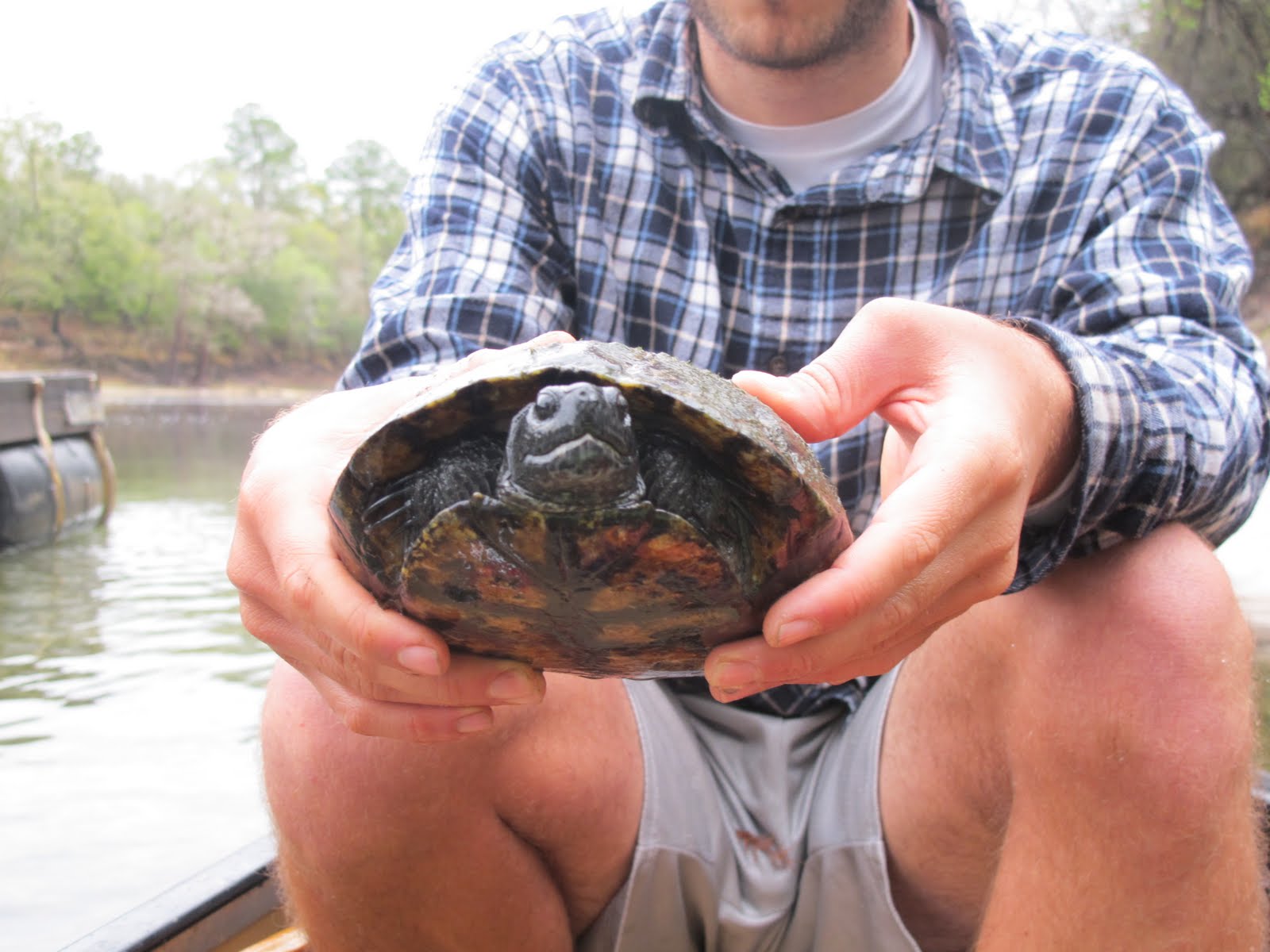
So, it began. Chris was determined to catch a turtle. And not just any turtle, one large enough to be made into turtle soup. It was our mission. We tried everything from sneaking up to them and netting them, to throwing pieces of limestone from long range to knock them out. Some of the rocks we found were too large and we threw our arms out pretty bad attempting to clock a turtle on the head. Needless to say, we never hit one. We came close a few times, but otherwise were not successful. Chris did net a few smaller turtles though:


After being distracted by turtles, Chris and I saw a large group of kayaks and canoes sitting on the shore of a sandbar. Dozens of people were basking in the sun, eating, drinking, hanging out. We didn't know it then, but we would actually be in contact with these people for the next few days. We had heard rumors of a "Baylor party" the night before at Wood's Ferry. So, we assumed that this was the group.
Chris and I have a bad competitive streak, it might have to do with growing up in large families with dads who strove to make their kids far too interested in coming out on top. I wouldn't call it a bad thing. But, from then on, we HAD to be ahead of that group. We spent the whole day speeding our paddling because we would see them rounding a corner and getting close to us. We stopped for a quick lunch at one point and they actually passed us. HOW DARE THEY. Chris and I hit the water and paddled without stopping the rest of the day so we could make it to the campground first.
Despite our competitive nature, we still stopped to see some cool places.

Apparently it was common to wall in a spring with a stone structure in the early 1900's and before. We saw multiples of these throughout the trip. This one in particular we met a cool old couple that wished us luck on our trip.


You can see the black, tannin water of the Suwanee mixing with the clear water from the spring.


Wait, what are those? Turtles? Negative. PIGS!
That's right, wild pigs! If my memory serves me well, Chris told me the Spanish brought them over as a source of food when first exploring Florida. There were literally 20 or more of these including little piglets and big males. The moment they spotted us we listened to them scurry into the woods like a bulldozer. They are really bad for the local vegetation.
The most surprising part of our day came when we managed to get to our river camp before sunset. I don't think I've ever set up camp with Chris Matechik with the sun still shining. I forgot to explain the actual river camps that we stayed in. They are essentially raised platforms with mesh covering the entirety of the structure, and screened in, so not only are you free of mosquitoes, but raccoons as well!
They were free, and most of all comfortable and kept us out of the elements. We were also able to leave our tents behind to save on space within the boat. They had a fan with a light on the inside, and even 2 electrical outlets to charge phones, lights, and cameras. The light was extremely useful, not wearing a headlamp while cooking, setting up, and just about everything is really nice.


Chris and I got in early to our camp, but we didn't want to lay around and fall asleep from exhaustion. So, we went on a hike in the area just to see what was around. The picture below is a pit that represents the starting of a sink hole. Chris wanted me to take it so he could show his professor. Chris is on the other side to show the size of the hole.

I took these photos strictly for Reema, she knows why.


To keep from deforesting the area, you buy logs from the river camp attendants. The two attendants at Holton Creek river camp were cool. They were a couple from Seattle that bought a trailer and had been traveling the U.S. I had some cash on me and paid $5 for five logs. We made a fire to cook on and bolster spirits in the cold weather.

Dinner consisted of probably the tastiest baked potatoes I've ever had. We smothered them in some olive oil I brought and added a little bit of salt too. Chris put them on the metal grate over the fire and we let them roast for probably about an hour. We used all of our random pots and pans to close them in so they would essentially "bake". I had another can of baked beans that we put on top for some flavor, and a can of green beans for some veggies!

Just look at this excited face.

Chris and I actually brought a little bit of home brew on our trip, and we divulged. We actually got pretty tipsy on night 2 after drinking a bottle of wine, some beer, and some cider. Here is an awful picture I tried to take with a 30 second exposure on my lens. It's blurry because the lens is manual and I wasn't in the right state of mind.

You can see Orion's Belt :3
Day 3

Paddling time and mileage (8:00AM-5:00PM, 27 miles)
Chris and I were prepared for the 3rd day. We had planned the trip to be a buildup and then easing as the days went on. The 3rd day was the peak of the cliff, we had to paddle 10 more miles than any other day. We decided to get up early and put in the river quick so we could paddle during the daylight since the nights were so cold.
We were first awoken by the Baylor party (which, to clarify, was a group of Outdoor Adventure students from Baylor University). The group consisted of something like 10-12 people, 2-3 of which were river veterans that were interested in getting the group down the river in a decent amount of time. They woke up about 5:00AM and scurried around the campsite making noise and making their hot breakfast of who knows what. It took them almost three hours to get onto the river after first waking up. Chris and I, on the other hand, woke up at 7:00 and tossed around until 7:45. We packed everything in 5 minutes, ate some clementines and crackers and loaded the canoe.
When the Baylor party saw us getting into our boat 10 minutes after saying goodbye to us, they were confused.
One guy asked,"Didn't you just wake up 10 minutes ago?"
"Yeah, we pack quickly."
"Uhhh."
So, we actually began to get to know the big group. They were all baptists going to Baylor University and decided to spend their Spring Break braving the Suwanee river. They put in at a park in White Springs 5 miles up river from where we started. They were all really nice people, but they didn't drink so Chris and I couldn't share our home brews with them.


Unbeknown to us, the 3rd day of our trip was national pirate day. The Baylor group had water cannons, pirate swords, and pirate hats. We felt out of the loop, but were glad to not have all the extra baggage.
There isn't much to talk about for day 3. Some stuff will be mentioned, but I honestly spent most of the day putting a paddle through the water. We had to cover a lot of ground and my pictures suffered. I think I had a good balance though. For the rest of the trip, I didn't take too many more pictures like on the first few days. I had more pressing matters to focus on. Also, I needed to enjoy the trip for myself and stop worrying about recording it!

Sometimes you forget civilization is only a few miles away in every direction when you don't see another human being for hours and hours at a time.

We didn't heed the warning

MRAHHRNNHH NRAHNNHNHRNRHN (AKA: quack quack)
After a long morning of paddling, Chris and I ended up in Suwanee River State Park. We stopped for a lunch of tuna tortillas, jimmy john's bread, and I believe an MRE.

Here was another reminder of civilization

It's exactly what you think it is. A book exchange at the state park for travelers, paddlers, RVers, snow birds, just about anyone. There was a Georgia map that I grabbed since Reema likes maps so much.

The picture above served as our map for the rest of the trip. No lie. Anytime Chris and I needed a rough estimate of where we were, I would pull out the camera and we'd look at this image. The numbers are mile markers, which made us feel better about how far we'd gone. The State Park was at mile 127.7, and we were headed to 76. So, we hit our half way point sometime on Day 3.

After we left the park we actually witnessed something Chris had always dreamed of. The sturgeon sign was a good find, because not an hour after leaving lunch at the park a 6-foot sturgeon leaped out of the water about 20 feet from our boat. I've never seen Chris so excited. We paddled a little wearily with the prospects of another Sturgeon throwing our boat over, but we didn't see anymore the rest of the journey.

About half way down the river from Holton Creek to our next river camp, Chris saw him. The turtle for our soup. He had me paddle furiously to the left of the river to get in close. The turtle tried to back into a rock and got stuck and Chris jumped out after him. We spent a little time looking at him, Chris told me he wouldn't kill the turtle but still wanted to eat it. I couldn't kill the turtle either, so we ended up throwing him back.

The turtle saying thanks

Here's another one of those slippery sliders

I think all the books tell you that vultures circling overhead is a bad thing. You can also see something like 60 vultures all through the trees. No thanks.
Just before reaching the river camp, Chris and I were a little tired from the long day of paddling to say the least. But, there they were on the horizon. A canoe with 3 people all paddling together, they must have just gotten into the water. Chris and I didn't say a word, our boat started moving quick. We wanted to catch and pass them, we have a problem you see. We paddled furiously around 2 corners and gained almost a quarter mile on them (which is a big deal if you have ever paddled a canoe before). Just as we were coming within a few hundred feet of them, the river camp sprung up. Oh well, we tried!

Chris and I were completely dumbfounded, again, as we reached camp before dark. The river camp had a steep beach to get up, but the platforms were twice the height of the ones from the night before. We were a good ten feet off the ground.

These are the mile marker signs at each river camp and state park. They were helpful to get an idea of how many miles we had done in how short a time. The 14.5 miles from the park to the camp were bland. The river widens A LOT after you hit the Suwanee River State Park. It doubles in size, easy.
The river camp attendant told us that there was a little village across the water we could go visit if we were interested. We showered up (yes, showered) and put on some nice clothes before paddling to the other side and heading up into the little town.

The town was terrifying. It was a creepy little retirement community where we didn't see a single human being for almost an hour. We walked around looking for a convenience store or restaurant to no avail. Apparently, everything closes at 5:00PM in the Advent Christian Village. The little community still lives in the 1950's.

Chris and I walked towards a blinking stoplight near a main road after having no luck in the village. We managed to see a JIFFY FOOD STORES sign just up the road and walked the quarter mile.
Let me just say, what a horrible horrible mistake. Two hungry guys that have been paddling for days, eating canned food and bread, and not drinking anything but spigot water from the local camps. The shelves were lined with cold soda, juices, gatorade and powerade. There were chips and hot pizza, candy, pop-tarts. Chris and I were literally two kids in a candy store and we needed to leave right away. He bought a large Pepsi and I tried to watch my dehydration by getting a powerade. We also bought a bag of Ranch Doritos and some peanuts. We managed to get out of the store spending $10 when we were likely to spend $100.
The Baylor group showed up as we got back to camp, about 2 hours after we had. The Baylor group was prone to stopping frequently as some of there members weren't up to continuous paddling.
Chris and I had dinner. Outside of the platform. We met a really cool guy who had been hiking a trail that followed the same path as our river trail. He had started in White Springs too, and was leaving the next morning. Funny thing was, he went to the exact same gas station as us. When at the gas station we told the lady about him, she had thought he was homeless because he was wearing a backpack, covered in dirt, and asking for directions.
Sleep.
Day 4

Paddling time and mileage (9:00AM-3:00PM, 17 miles)
Day 4 was awesome. Chris and I got up around 8:00AM, and we knew we had a really short day of paddling ahead of us. The Baylor group was leaving as we did, again. We didn't see them again, though. We passed them immediately and they were long behind. The leader of their group did warn us that the weather would turn sour later that day, and to keep an eye out.

The river widened.
And then it came.
Wind.
Oh god, paddling in the wind is miserable. Imagine paddling a canoe forward and feeling like you are going no where. We paddled and paddled down each stretch, the day ended up feeling as tiring as the 27 mile from the day before.
During our paddle, we saw some canoes up ahead.
Needless to say, we gunned for them.
We caught up quickly around a few bends and began passing them. They were more or less the kind of people we would have rather met. College students, from Virginia College. They were all pretty laid back, and there trip was just as long as ours (they left from White Springs only 5 miles up river, and were heading to Branford too). However, they had 2 extra days to paddle, 7 in total. They were also uninterested in the river camps and were roughing it in tents on the shore. I think it was a pride thing, but Chris and I figured the platforms were free, so why not use them?
We said our hellos and goodbyes, and paddled ahead of them, leaving them far behind.
We rounded a few bends and saw a sign for Lafayette Blue Springs. Chris remarked at how clever the explorers of America were, naming every single spring 'blue spring'. Oh, the water is blue, what should we call it?
It was in the high 60's to low 70's, so it wasn't the warmest weather. Also, the spring was about 62 degrees, as most are. But, Chris wanted to swim in a spring before the trip was over. He told me if he got in I had to also. Hence, the following video:
The spring was well worth the cold water, and the land bridge was awesome to swim under. Chris and I grabbed the Doritos we had bought the night before and heated up a can of re-fried black beans. A Mexican inspired lunch for sure. The food was great, and we hit the water again after about an hour break. The kids we had passed not too long before had finally caught up as we were leaving.

I was attempting to give an idea of how long the stretches were after each bend we made in the river. It doesn't do it justice in the photo. It was a great morale booster to see large segments of the river behind you, but disheartening when you saw the next one. We paddled still!

The blue bridge was the last cool thing that we saw on Day 4. We mostly paddled, and were weary of the incoming bad weather.
We arrived at Peacock Slough River Camp at 3:00PM and were once again shocked by our quick finish.
We once again set out on a hike to see the local terrain. We stumbled through the "slough" which was a dried up creek bed that had been torn apart by wild pigs. Chris saw something awesome in the distance at one point, and we climbed out of the creek bed to see the find.
Flowers in gardens are cool, but a whole field of flowers in the middle of the forest? That was something else. Lilies, everywhere. I sprinted back to the camp and grabbed my 1000d to take some photos. Nothing special, but they turned out nice!


We knew about the impeding bad weather, and the clouds were beginning to approach overhead. We met the river camp attendants, they were a couple that migrated between campsites in Georgia where they were paid and the free camps like on the Suwanee. They were heading into town to buy groceries and offered to pick us up some things. I had them get some mushrooms and onions which Chris put into our dinner. Dinner consisted of macaroni pasta, tomato sauce, and sauteed mushrooms and onions. It was a great meal, and Chris and I weren't able to even finish all of it.
The rain finally hit, and the storm was brutal. The wind picked up a lot, but we managed to hole up in our shelter. Before night fell we heard a huge crash. A huge tree fell not 15 feet from our shelter, luckily in the opposite direction. While falling, it took out yet another tree with it. Widowmakers...no thanks.
The storm was nice to sleep to, and we decided that we both wanted to be able to drive home to our respective towns after finishing the trip on Day 5. We finally agreed on waking up at 4AM to begin our last day so we could finish around noon. We ended up going to bed at 8:30PM, and had a pretty long night sleep.
Day 5

Paddling time and mileage (5:15AM-11:30AM, 21 miles)
We actually slept in until roughly 4:30-4:45 before loading up the boat. We ate a few packs of peanut butter crackers and the last two clementines. The rain had stopped, and we were anxious to get out on the river. It was pitch black and we paddled the first few hours without any light. The above picture was actually the first stop we made at Royal Spring at about 6:30 in the morning.
The picture below is Chris, tired from an early start. And probably mad that I was taking photos and not paddling. As you can see, the river stretches had become something like 1/2 a mile.

At a spring, which had no name to be found, Chris managed to snag up another turtle to eat. Once again, we decided against it. This little guy had scars all over his shell and had probably seen better days. But, he was still alive and kicking.
I couldn't document most of Day 5 due to lack of light, but we were tired and ready to warm up in our respective cars. We paddled farther in a shorter amount of time on the last day than any other, our paddling prowess had grown throughout the trip.
The Suwanee River Wilderness trail was awesome! I recommend it to anyone who likes canoeing or kayaking. The river camps are convenient, and you meet some pretty awesome people. I'll link to some of our youtube videos soon.
No comments:
Post a Comment